Dzongri trekking videos are published in 3 parts on YouTube
as per following links below. Watch all for complete information.
Part 1: https://youtu.be/uQecCvonCJs
Part 2: https://youtu.be/RhhkJBBmCTo
Part 3: https://youtu.be/Q-1ErYqM_Koজংরির জঙ্গলে কয়েকটি দিন
 |
| Dzongri top |
২০১৫ মে মাসের দিতীয়
দিন . কামরূপ এক্সপ্রেস ছুটে চলেছে আমাদের নিয়ে নিউ জলপাইগুড়ির দিকে . এবার
ট্রেকিংএর সদস্য মাত্র দুজন তমঘ্ন আর আমি . মনে আত্মবিশ্বাস নিয়ে কোনো মতে বেড়িয়ে
পড়েছি . সদস্য কম হয়ার জন্য নিজেদের মনকে এটা ভালোভাবেই বুঝিয়ে দিয়েছি যে ট্রেক টা
যতটা সক্ত জানতাম , আমাদের জন্য আরো অনেক বেশি বাধা বিপত্তি পূর্ণ হতে চলেছে .
নিজে দের শারীরিক ও মানসিক দক্ষতার এক্স শতাংশ উজাড় করে না দিতে পারলে হয়তো আমরা
আশা অনুরূপ ফল পাব না . ট্রেক টির প্রস্তাব কি ভাবে এসেছিলো সেই মুহূর্ত গুলোই আজ
বার বার মনে পড়ছে.....................
২০১৪ নভেম্বর দিতীয়
সপ্তাহ দুপুর গড়িয়ে বিকেল হতে চলেছে . একটা SMS এল “ অনেক ক্ষণ থেকে ফোন করছি ,
ফোন টা তোল”.....তমঘ্ন . ফোন করতেই বিস্ফোরক প্রস্তাব ... সামনের বছর একটা ট্রেক
কি করা হবে , দেখা কর আলোচনা হবে . মিটিং হল অনেকেই যাবার ইচ্ছা প্রকাশ করল . ঠিক
হল জংরি গোচালা যাওয়া হবে . কিন্তু ট্রেনএর টিকিট কাটার সময় সদস্য মাত্র তিন জনে
ঠেকলো . ট্রেক ছোট করা হল , ঠিক হল আমরা জংরি পর্যন্ত যাব – কারণ এখান পর্যন্ত
থাকা খাবার ব্যবস্থা আছে . সব ঠিকঠাকি চলছিল কিন্তু দিন দুএক আগে রঞ্জনদা টিকিট
ক্যানসেল করালো . পড়ে রইলাম মাত্র দুজন তমঘ্ন আর আমি . অনেক বাধা বিপত্তি সত্তেও
আমরা সাহস করে বেড়িয়ে পড়লাম .
 |
| Yuksome |
নিউ জলপাইগুড়ির
পৌঁছাবার কথা সকাল ৬:১৫ নাগাদ , কিন্তু ট্রেন লেট করে ৮:০০ টা বাজিয়ে দিল . ঠিক
ছিল আমরা জোরথাং হয়ে যাব . NJP থেকে জোরথাং যাবার শেয়ার ট্যাক্সি পায়া যায় না ,
অটো ধরে গেলাম SNT বাস স্ট্যান্ড . 9:৪৫ ট্যাক্সি ছুটে চল্লো জোরথাংএর দিকে , ভাড়া জন প্রতি ২০০ টাকা . ৩ ঘন্টা পরে
আমরা জোরথাং পৌঁছালাম . জোরথাংএর ট্যাক্সি স্ট্যান্ডটা খুবই আধুনিই, তিন তলা . এখান
থেকে সিকিমএর ভিতরে বা বাইরে যেকোনো জায়গায় যাবার শেয়ার ট্যাক্সি পাওয়া যায় .
ইয়াকসাম যেতে হলে তিন তলা থেকে ট্যাক্সি ধরতে হয় . দুপুরের লাঞ্চ সারলাম মোমো দিয়ে
. ১:৩০ শে আবার যাত্রা শুরু করলাম , গন্তব্য ইয়াকসাম ভাড়া জন প্রতি ১৫০ টাকা.
প্রায় সাড়েতিন ঘন্টা পরে অবশেষে যাত্রা শেষ হল .
ইয়াকসাম
হোটেল DEMAZONG এর
সামনে গাড়ি থেকে নামলাম . হোটেলের OWNER রব (০৯৭৭৫৪৭৩৬৮৭) . প্রথমেই বলে রাখি আগে থেকেই রবের সঙ্গে কথা বলাছিল , ছেলেটি প্রচন্ড
হেল্পফুল . ৩০০ টাকার বিনিময়ে দোতলায় একটি ঘর দিল . ঘরটি বেস বড় – ট্রেকার দের
জন্য খুবই ভালো . রব’ই গাইডকে ফোন করে দিল পরের দিন সকাল সাতটায় আসার জন্য . ফ্রেশ
হতে হতেই সন্ধে নেমে আসলো . সময়ের সল্পতার জন্য সহরটি আর ঘুরে দেখা হল না . খাবার
জায়গা দুটি গুপ্তা রেস্টুরেন্ট আর ইয়াক রেস্টুরেন্ট . আমরা ইয়াক রেস্টুরেন্টটে
মাংস রুটি দিয়ে ডিনার সারলাম . পরের দিনের জন্য ব্যাগ গুছিয়ে নিয়ে রাত্রি নটায় মধ্যে
শুয়ে পড়লাম .
 |
| Kabru from Yuksome |
 |
| Trek start point at Yuksome |
সকালের টিফিন সারলাম
ব্রেড , বাটার , চিনি আর এক গ্লাস করে ছাতু দিয়ে . ইতি মধ্যেই আমাদের গাইড অনুজ
চলে এসেছে কিন্তু পোর্টার জোগার হয়নি . শেষ মেষ ঠিক হল অনুজই বড় রুক্সাক, স্লীপিং
ব্যাগ আর টেন্ট নিয়ে যাবে তার জন্য তাকে দিন প্রতি ১১০০ টাকা দেয়া হবে . তমঘ্ন
অনুজকে নিয়ে পুলিশ চৌকিতে নাম এন্টি করতে বেড়িয়ে গেল আমি ব্যাগ গুছিয়ে বোতলের জলে গুলে
নিলাম টাং . টাং হল আমাদের নতুন সংযোজন দারুন একটা এনার্জি ড্রিংক . রব একটা গাড়ি
ঠিক করে দিল যেটা আমাদের ট্রেকিংএর স্টার্টিং পয়েন্টএ পৌঁছে দেবে . ৮:১০ এ আমরা
যাত্রা শুরু করলাম . প্রায় তিন কিলোমিটার দূরে গাড়ি আমাদের নামিয়ে দিল . এখান
থেকেই হাঁটা শুরু ......
দুই পাসে সারি দিয়ে
একতলা দুতলা ঘরবাড়ি, মাঝ বরাবর সংকীর্ণ পাথুরে রাস্তা চলে গেছে . প্রিতিটি বাড়ির
বারান্দায় বা উঠানে সারি সারি ফুলের গাছ, পাহাড়ের এ’এক অতি পরিচিত দৃশ্য . গাইডকে
পিছনে ফেলে আমরা এগিয়ে চলেছি অজানা পথে . মিনিট পাঁচেকের মধ্যেই ঘর বাড়ি সব দৃশ্য
পট থেকে হারিয়ে গেল . আমরা পাথুরে চড়াই রাস্তা ধরে নিবিড় বনানীর মধ্যে প্রবেশ
করলাম .

 |
| Sanctuary gate |
এই মনরম দৃশ্য
উপভোগ করতে করতে এগ টোস্ট দিয়ে সকালের পেট পুজো সারা হল . এই জায়গাতে মাছি জাতীয়
পোকা মাকড়ের প্রচন্ড উপদ্রোপ . ইতি মধ্যেই আমাদের গাইড অনুজ পৌঁছে গেছে .
আবার এগিয়ে চলা, কখনো
চড়াই কখনো উতরাই . চারি দিকে জঙ্গল আর জঙ্গল, দেওদার জাতীয় গাছ’ই বেশি . এই ভাবেই
প্রায় ঘন্টা খানেক চলার পরে পাহাড়ের এক বাঁকে দেখা গেল দ্বিতীয় ব্রিজ . এটিও লোহার
ক্যাবল দিয়ে বাঁধা সাসপেন্সান ব্রিজ . এর নিচে দিয়ে থুসু খোলা বয়ে চলেছে . এখানেও
মাছি জাতীয় পোকা মাকড়ের প্রচন্ড উপদ্রোপ . কেক বিসকুট দিয়ে হালকা টিফিন সারা হল .
ইতি মধ্যে একটি রাশিয়ান টিমএর দেখা পায়া
গেল . জনা সাতেকের দল, সঙ্গে গাইড পোর্টার ইয়াক এর ছরা ছরি . এরা যাচ্ছে রেড
পান্ডার সাথে . এতক্ষণ পরে একাকিত্ব কাটল . কথাবলার একটু লোক পায়া গেল .
 |
| 4th bridge |
এই ভাবে চলতে চলতে
তৃতীয় ব্রিজ এসে পৌঁছালাম . এটি একটি কংক্রীড় ব্রিজ . এখান দিয়ে বয়ে চলেছে
মেনটোঙ্গা খোলা . নদীতে জল নেই বললেই চলে . একদল ইয়াক উপর থেকে নিচের দিকে নেমে
চলেছে . ইয়াকের গলার ঘন্টার টুং টুং শব্দে চারি দিক ভরে গেল . চিরেভাজা আর বাদাম
দিয়ে আপাতত পেটের ইদুর গুলোকে চুপ করালাম . আজকের পথ অতি দীর্ঘ তা আগে থেকেই জানা
ছিল, তাই সময় নষ্ট না করে আবার হাঁটা দিলাম . কিছুদুর যাবার পর রাস্তার একটু উপরে
দুটি টেন্ট দেখা গেল . বুঝতে অসুবিধা হলনা আমরা সাচেন চলে এসেছি . রাস্তার কিছুটা
নিচে একটি লগ হার্ট রয়েছে . যারা এক দিনে বাখিম বা সোকা যেতে পারেনা তাদের জন্য
এটি একমাত্র থাকার জায়গা . আবার যারা ঘন জঙ্গলের মধ্যে রাত্রিবাস করতে ভালো বাসে
তাদের জন্য এর থেকে আদর্স কিছু হতে পারেনা . যাই হোক আমাদের আজকের গন্তব্য সোকা
তাই মায়া না বাড়িয়ে এগিয়ে চলাই আমাদের জন্য আদর্স হবে . হটাথই উতরাই রাস্তা শুরু
হল নামছি তো নামছি . আবার সেই খিন সব্দ অতি পরিচিত . সেসমেশ নেমে এলাম চতুর্থ
ব্রিজে . এটিও লোহার ক্যাবল দিয়ে বাঁধা সাসপেন্সান ব্রিজ তবে এটির আকার প্রকান্ড .
অনেক নিচে দিয়ে বয়েচলেছে প্রেকচু নদী . বিশাল তার জলরাশি আয়জও গুরু গম্ভীর .
ব্রিজের চারি দিকে প্রেয়ার ফ্ল্যাগ উড়ছে . পাহাড়ের গা বেয়ে বিশাল একটি ধস নদী
পর্যন্ত নেমে এসেছে . এই দৃশ্য কখনো ভোলার নয় ! এবার শুধুই চড়াই .
 |
| Bakhim |
চতুর্থ ব্রিজ থেকে
বাখিম পর্যন্ত পুরোটাই চড়াই রাস্তা . গাছের ছায়ার মধ্য দিয়ে আলো-আঁধারী রাস্তা ধরে
আমরা এগিয়ে চলেছি . পায়ের তলায় পড়ে আছে শুকানো পাতা, এর উপর দিয়ে হাঁটার সময় যে
মস-মস করে সব্দ হয় তা বেস রোমাঞ্চ কর লাগছিল . এই ভাবে হাঁটতে হাঁটতে প্রায় এক ঘন্টা
পরে আমরা বাখিমে পৌঁছে গেলাম . পাহাড়ের ঢালে একটি পরিবার বাসকরে . থাকার কোনো ঘর
নেই কিন্তু খাবার পায়া যায় . টেন্ট গ্রাউন্ড আছে
কিন্তু বন দপ্তরের বাংলোটা ২০১১এর ভূমিকম্পে বাপক ভাবে ক্ষতিগ্রস্ত হয়েছে
বলে ওখানে আর থাকতে দেয়না . এখান থেকে ইয়াকসামের একটি অংশ দেখা যায় . গরম চা আর
নুডুলস দিয়ে পেট পুজো সেরে আবার হাঁটা দিলাম . ইতি মধ্যেই চারি দিক কুয়াশায় ঢাকা
পড়ে গেছে . শরীর ক্লান্ত হয়ে এসেছে, কোনো মতে আর তিন কিলোমিটার যেতে পারলেই আজকের
গন্তব্যে পৌঁছানো যাবে . এই ভাবে চড়াই ভাঙ্গতে ভাঙ্গতে এগিয়ে চলেছি . হটাথই দেখি
রাস্তার মাঝে থোকা থোকা সাদা ফুলে ভরা একটি গাছ . বুজতে অসুবিধা হল না এটি
রডডেনড্রন . ভেবেই ভালো লাগলো এবার থেকে মাঝে মাঝেই গুরাস দেখা যাবে . রডডেনড্রন
এখানে গুরাস নামেই পরিচিত . আমাদের গাইড আগে চলে গেছে তাই বুঝতে পারছিলাম না আর কত
দূর যেতে হবে . মনে হল কুয়াশার আড়াল থেকে কে যেন ডাকছে . রাস্তা ছেড়ে ডানদিকে
এগিয়ে গেলাম, সারি সারি টেন্ট ক্যাম্পিং করা রয়েছে . ও আমরা সোকা চলে এসেছি . এত
ঘন কুয়াশা পড়েছে যে দশ ফুট দূরে কিছু দেখা যাচ্ছেনা .
সোকা
 |
| Tshkoa |
সোকার টেন্ট গ্রাউন্ডটা
বেস বড়, প্রায় ন’টা টেন্ট পিচ করা আছে . পোর্টার গাইড ট্রেকার মিলিয়ে অনেক লোক .
দুটি বড় মাপের রান্না ঘরে হই হই করে রান্না হচ্ছে, পাসে রয়েছে বেস বড় একটা ডাইনিং
রুম . ব্যাগ টেন্টের মধ্যে রেখে বাইরে ঘোরা ঘুরি করতে লাগলাম . জমিয়ে ঠান্ডা
পড়েছে, আকাশও পরিস্কার হতে শুরু করেছে . সাতটার মধ্যে রাতের খাওয়া সেরে টেন্টে চলে
এলাম . রাত্রে ঘুম অল্প হলেও সকালে শরীর বেশ তরতাজা মনে হচ্ছে . টেন্ট গ্রাউন্ডএর
ডানদিকে পান্ডিম তেনজিংখাং ঝুপনু নরসিং সারি বদ্ধ ভাবে দাঁড়িয়ে আছে .
পান্ডিমএর মাথা সূর্যের প্রথম আলোকে লাল
হয়ে উটছে . গাড় নীল আকাশের মধ্যে রক্তবর্ণ পান্ডিমএর এই রূপ দেখে মন ভরে গেল . ব্রেড
, বাটার , চিনি আর এক গ্লাস করে ছাতু দিয়ে উপস ভঙ্গ করলাম . ব্যাগ গুছিয়ে বেরোতে
বেরোতে আট’টা বেজে গেল . হাঁটা শুরু হল, দিনের আলোতে বোঝা গেলে সোকা জায়গাটা বেশ
বড় . ওপরে আরো একটা টেন্ট গ্রাউন্ড আছে . রাস্তার বাঁ’দিকে রয়েছে মনেস্টি তার
সামনে একটি জলাসয় . রাস্তার ডানদিকে রডডেনড্রন গাছের সারি . গাছে কোনো পাতা দেখা
যাচ্ছে না শুধু থোকা থোকা লাল গুরাসে ভরে আছে . সব মিলিয়ে সোকার প্রাকিতিক
সৌন্দর্য অসামান্য . চড়াই রাস্তা ধরে উপর দিকে খানিক ওঠার পর পিছনে ফিরে দেখি অনেক
নিচে সোকা গ্রামকে এক ফ্রেমে দেখাযাচ্ছে . এই দৃশ্য ক্যামেরা বন্দী না করে এগিয়ে
যেতে পারলাম না .


চারি দিকে শুধু গুরাস
আর গুরাস তার মধ্য দিয়ে কাঠের গুড়ি পাতা রাস্তা . মনে হচ্ছিল কোনো পার্কের মধ্যে
আছি, সাদা লাল গোলাপী হালকা বেগুনী হলুদ গুরাসের যে কত বর্ণ হতে পারে এখানে না এলে
তা জানতেই পারতাম না . মাথার উপর নিল আকাশ, চারিদিকে বর্ণময় গুরাস, গভীর জঞ্জলের
মধ্য থেকে তুষার শৃঙ্গের লুকোচুরি – এই দেখেতে দেখেতে পৌঁছে গেলাম ফেদাং . জঙ্গলের
মধ্যে কাদা ও সবুজ ঘাসে ভরা এই ফেদাং ভ্যালি . ফেদাং থেকে দুটি রাস্তা, একটি জংরি
অন্যটি কোকচুরুং’এর দিকে চলেগেছে . ভ্যালির বাঁ দিকে রয়েছে কাঠের একটি ঘর . এখানে
রাত্রিবাস করা যায় তবে জলের সমস্যা আছে . ভ্যালির ডানদিক দিয়ে যে রাস্তা টি
কোকচুরুং’এর দিকে চলে গেছে সেই রাস্তা ধরে কিছু দূর গেলে তবে জল পাওয়া যায় . আজ
আমরা বিনি পয়সায় আলু আর ডিম সিদ্ধ পেলাম, পুরোটাই আমাদের গাইড অনুজের কৃতিত্ত . এখানথেকে
ভালো ভিউ দেখা যায়, কিন্তু আমরা তা পেলাম না কারণ আকাশ মেঘে ঢাকা পড়েগেছে . যাইহোক
আবার হাঁটা শুরু হল . ঘন্টা খানেক চড়াই ভাঙ্গার পর আমরা ধ্বসে জায়া পাহাড়ের এক
ঢালে উপস্থিত হলাম . রাস্তা এখানে প্রচন্ড চড়াই তার উপর উল্টো দিক থেকে ইয়াক নামছে
. পায়ের তলায় ঝুর পাথর বালি অতিক্রম করে আমরা সারিবদ্ধ ভাবে এগিয়ে চললাম . সামনেই
দেখা যাচ্ছে প্রেয়ার ফ্ল্যাগ উড়তে, দেওরালি এসে গেছে .
 |
| Deorali |
এটি মধ্যেই তমঘ্ন মাথায়
যন্ত্রণা অনুভব করতে লাগলো, altitude sickness . খানিক বিশ্রাম নেয়া ছাড়া কোন উপায়
নেই . মাথা যন্ত্রণার ওষুধ খেয়ে তেমন কোন লাভ হবে বলে মনে হয় না . আরো অনেক সহ
যাত্রীরা একই ভাবে বিশ্রাম নিচ্ছে . একটা পোর্টারএর অভিজ্ঞতা কাজে লাগল ‘গলুকোস ওয়াটার’ – পাঁচ মিনিটেই একদম
সুস্থ . চিরেভাজা আর চকলেট দিয়ে এনার্জি লেভেলটা কিছুটা বাড়িয়ে নিলাম . এখানেও
রডডেনড্রন গাচ্ছে ভর্তি তবে ফুল নেই . গাছের তলায় বরফ জমে আছে . আকাশ একই ভাবে
মেঘাছন্ন হয়ে আছে . আবার যাত্রা শুরু হল, এবারের রাস্তা সমতল . মিনিট দশেক পর শেষ
চড়াইয়ের সামনে এসে দাঁড়ালাম . চারিদিক রডডেনড্রন বেষ্টিত বরফ জমে থাকা একটা
উন্মুক্ত প্রাঙ্গন, পাসে রয়েছে শুকিয়ে জাওয়া একটা লেক আর কুয়াশায় আলো আঁধারী আবরণে
ঢাকা মায়াবী প্রান্তর . চারিদিক এত নিস্তব্দ প্রাকিতিক সৌন্দর্যে ভরা পা নিশ্চল
চোখ নিস্পলক হয়ে যাবে . যাই হোক মায়া কাটিয়ে বাস্তবের চড়াই চড়তে শুরু করে দিলাম .
এবার উতরাই পথে কিছুদূর গেলেই আজকের গন্তব্য . উতরাই পথ যেন শেষ হচ্ছে না শরীর অবশ
হয়ে আসছে, পায়ে পায়ে জড়িয়ে যাচ্ছে . গন্তব্যের খুব কাছে চলে এলে সাধারণ ভাবে
মানসিক দৃঢ়তা শিথীল হতে থাকে এটা তারই প্রমান . অনেকটা ঘোড়া দেখে খোড়া হওয়ার মত .
যাই হোক সামনে অনুজ কে দাঁড়িয়ে থাকতে দেখে শরীরের ক্লান্তি দূর হল . অবশেষে স্বপ্নের
জংরিতে পদার্পণ করলাম .
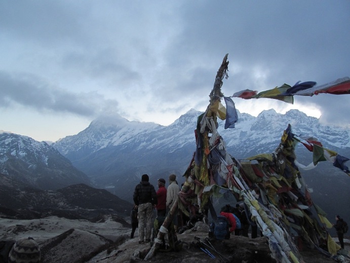
জংরি
 |
| Dzongri tent ground |
পাহাড়ের খাঁজে দুটি
ট্রেকার্স হার্ট আর দুটি হার্টের সামনে দুটি টেন্ট গ্রাউন্ড আছে . দিতীয়
গ্রাউন্ডএর সামনেই নিল-সবুজ রঙের আমাদের টেন্টটি খাটানো হয়েছে . চারি দিক দিয়ে
পাহাড় বেষ্টিত হওয়ার জন্য প্রবল বাতাস না বইলেও ঠান্ডাটা জমিয়ে পড়েছে . একটা সরু
জলধারা বয়ে চলেছে যা এক মাত্র লাইফ লাইন . ক্লান্ত শরীর কে রেস্ট দেবার জন্য
টেন্টে প্রবেশ করলাম . ক্লান্তি কিন্তু কাটছে না উল্টে শরীর আরো খারাপ হতে শুরু
করে দিল . তাই দেরি না করে টেন্ট ছেড়ে বেড়িয়ে পড়লাম বাতাসের অল্প অক্সিজেনের সাথে
শরীর টাকে খাপ খায়াতে হবে, এটাই এক মাত্র ঔষুদ . হাতে অনেক সময় থাকলেও করার কিছুই
নেই তাই গল্প করতে করতেই বিকেল গড়িয়ে সন্ধ্যে নেমে এল . সন্ধ্যে ৭টার মধ্যে ডাল, ভাত,
সব্জি আর ডিম ভাজা দিয়ে ডিনার সারা হল . আজ পরিশ্রম ভালই হয়েছে তাই ঘুম টাও ভালো
হল . ৩ টের এলাম বাজার আগেই ঘুম ভেঙ্গে গেল কিন্তু স্লীপিং ব্যাগ থেকে হাত-পা বার
করা যাচ্ছে না প্রচন্ড ঠান্ডা . কোনমতে বোতল খুলে এক চামচ ডাবর হানি মুখে পুরলাম
কিন্তু ঠান্ডার চোটে ডাবর হানি ক্যান্ডি’তে পরিনত হয়েছে তাই অগত্তা চুসেই খেতে হল
. স্লীপিং ব্যাগ থেকেতো বেরোলাম তবে বাঙালির একটা সভাব আছে চোখ খুললেই নেচার’স কল,
তার জন্য তো টেন্টের বাইরে বেরোতে হবে . এই সময়ের জন্য এটা খুবই কঠিন কাজ তবে করতে
হবেই . দিতীয় বারের জন্য ডাবর হানি’র সরনাপন্ন হোলাম . এই বারের মত কাজ টা উদ্ধার
হল . জিও ডাবর হানি!
 |
| view from Dzongri |
৪ টের মধ্যে টেন্ট ছেড়ে বেড়িয়ে পড়লাম জংরি টপ’এর রাস্তায় .
রাতের অন্ধকারে পাহাড় বেয়ে উপরে উঠতে শুরু করলাম, স মিলিয়ে প্রায় জনা কুড়ি হবে .
একের পর এক খাড়াই পাহাড়ের চুড়ায় উঠছি আর সামনের দৃশ্য পট উন্মুক্ত হয়ে চলেছে . বাম
দিক থেকে ডান দিকে খাং, রিঙ্ক, সাংরি, ককথাং, ফেরি, রথাং, কাবরু গ্রুপস,
কাঞ্চনজংঘা, শিম্ভো, পান্ডিম সব কটি এক সারিতে দাঁড়িয়ে আছে . রথাং, কাবরু সূর্যের প্রথম আলোতে রক্ত বর্ণ ধারণ করেছে .
একের পর এক সবার মাথাই রক্ত বর্ণ ধারণ করল . প্রচন্ড জোরে বাতাস বইছে ঠান্ডায় হাত
বার করা যাচ্ছে না ছবি তোলার জন্য . তবে এই মুহূর্ত কে ক্যামেরা বন্দী না করতে
পারলে সারা জীবনের আপসোস থেকে যাবে . আসতে আসতে তুষার শৃঙ্গ রক্ত বর্ণ থেকে সোনালী
ও সাদা হতে থাকলো . মুহুর্তের মধ্যে এক ফালি রোদ আমাদের গায়ে এসে পড়ল সরীরের সকল
জরতা কেটে গেল . এখানে প্রায় এক ঘন্টা সময় কাটালাম যা সারা জীবনে এক মূল বান সঞ্চয়
হয়ে থেকে যাবে . এটা সারা জীবন আমাকে মনে করিয়ে দেবে আমি নিজের শারীরিক ও মানসিক
ক্ষমতার গন্ডি পেরিয়ে কি করতে পারি . এবার ফেরার পালা................
If you want to do this trek as classic style then go with following schedule. It is the best schedule to do this trek.
Day
1: Getting to Yuksom, drive from NJP to Yuksom (6 hrs)
The Goechala trek starts at Yuksom, a fairly large
settlement in West Sikkim. It was once the capital of Sikkim, so the culture in
the town shows. It is also a nice quaint hill station and for those who want to
avoid the hustle bustle of Darjeeling, Yuksom is a nice gateway. There are plenty
of hotels in various budgets so staying is not a problem. A decent room with a
shared bath works out to about Rs 300. The costlier rooms are around Rs 1,500.If you are on the Goechala trek there are two important things to do
at Yuksom. One, make an entry at the police station. For this you need a photo
identity proof with three photo copies. Two, you need to pay the permit fees at
the forest check post (usually trekkers do this in the morning when
they are starting the trek). The fee to be paid is broken down into
small elements like tent, porter, yak and other charges. It can get somewhat
confusing, but the net amount will boil down to about Rs 700 per person.Foreigners have it slightly more
difficult. First, foreigners cannot trek alone; they need at least a partner.
Two, they need to get a trekking permit from Gangtok (which usually their
trekking agency will organize). Three, foreigners have to do the trek with a
trekking agency – they cannot trek on the trail by themselves. Finally, once
they enter Sikkim from any highway, their papers are going to be checked at the
border.Yuksom is also the last place to
buy provisions for the trek. So stock up well before you start the trek. You
get almost everything at Yuksom so there really isn’t any need to buy things at
Siliguri, Kolkata or Gangtok.
Day
2: Yuksom (5,700 feet) to Sachen (7,200 feet). 4 - 4 ½ hours.
Note: Most trekkers like to trek from Yuksom to
Tshoka in a day. This makes the trek very long and the altitude gain too much.
A sensible way to trek is to break the trek at Sachen as described here.From Yuksom, the Goechala trail
starts just behind the houses after the forest check post. Cross the last few
huts of Yuksom and skirt around the fields of Yuksom to enter the V shaped
valley of the Rathong river (many mistake it for the Prek – earlier Prek and
Pha Khola merge to form the Rathong).The trail, though passing through
the fringes of the forest is exposed for about half hour. Midway through the
exposed trail, look for a shelter on your right. From here onwards it is half
hour to the first bridge over the Pha Khola.By the time the trail gets to Pha
Khola, you are well into the thick of the forest and the coolness envelopes you
at all times. The gently undulating trail climbs gradually.The next hour and half is a
pleasant walk through the moist jungle until suddenly on your left the Tshushay
Khola falls in a series of mini waterfalls joining the Prek below. 50 meters
later a large iron bridge spans the Tshushay Khola. After the bridge the trail
begins to climb more noticeably.An hour later watch for another
small cement bridge over the Mentogang Khola (you won’t find a board telling
you the name). You are already at 7,100 feet and it is only twenty minutes from
here to the log hut of Sachen.Sachen at 7,200 feet is a small
clearing where a single log hut and a shelter on the trail exist. The log hut a
few meters below the trail. The hut has room enough for about 6-7 and a small
area to cook. For a larger team look for the clearing just above the trail
opposite the shelter. The Prek, is many feet below Sachen and not visible to
the eye, though you can hear it faintly rushing below.
Day
3: Sachen (7,200 feet) – Tshoka (9,650 feet). 3 ½ - 4 hours
This is a short trek, but the
altitude gain is considerable. Trekkers love the initial amble through the
forest – it gives them a chance to loosen up before the stiff climb to Bakhim
from the bridge over Prek.The trail out of Sachen undulates
but maintains an even altitude, in fact gaining a few feet until 45 minutes and
2 kms later you drop down to the bridge over Prek. The clear water of the Prek
is worth savoring. You don’t meet the river until three days later at
Kockchurang.The wooden bridge over Prek sways
when you walk over it. Adorned with multitude of prayer flags wishing success
to the expedition -- it signals the start of the real climbs of the Goechala
trail – climbs that stay with you until you get to Goechala.Take the trail that begins to
climb to the left of the bridge. The trail climbs sharp through a mixed oak
forest until the wide switchbacks level somewhat half hour later at the sight
of the first Rhododendrons. The altitude gain is rapid and the air gets cooler
perceptively. Soon the trail climbs to the ridge and stays there until you get
to Bakhim another half hour later. From the Prek it takes an hour to get to
Bakhim (the total distance is only a kilometer but feels a lot longer).Bakhim has a Forest Rest House
and some trekkers like staying at Bakhim – simply for its view of the Yuksom
valley. Finding the caretaker is a struggle and most trekkers move on to Tshoka
which is another hour away.Bakhim has a lovely tea stall
where the owner dishes out some snacks as well. With a well deserved rest start
your climb to Tshoka. Follow the trail just behind the Forest Rest House. The
trail again climbs in a series of long switchbacks, overlooking Bakhim until
forty minutes later it dives around a ridge to move to the other side of the
hill.At over 9,000 feet high,
Rhododenderon trees abound everywhere. The trail gets dark from the overhanging
trees and meanders for another ten minutes. It suddenly pops out to a plateau
and the trekkers hut of Tshoka. There’s also a flat camping area to the left of
the trekkers hut. The trekker’s hut is a pretty long wooden building that has
four rooms – enough space to house more than 20 trekkers. Alternatively,
trekkers can stay at the Forest Rest House slightly uphillSpend some time exploring Tshoka.
Slightly uphill are the cafes where trekkers can try the local malt beer Tumba.
The local Yak cheese is another delicacy but it takes time to get used to the
taste. It is rock hard too! Ask the café owners for the keys to the monastery.Follow the trail as it leads out
of Tshoka, cross the small wooden bridge over the pond and head to the
monastery. It is a quiet place worthy of a quick visit. But what will take your
breath away is the view of the snow clad peaks of the Kanchenjunga range
stretching right behind you – with Mt Pandim dominating the skyline. For most
trekkers this is the view of the day.
Day
4: Tshoka (9,650 feet) – Dzongri (12,980 feet) via Phedang (12,050 feet). 5 - 6
hours.
For most trekkers this day is
perhaps the highlight of the Goechala trail. Everyone looks forward to the trek
this day. For one, they trek through some of the densest Rhododendron forest
India has to offer, and second, on the trail, suddenly the views open up to
showcase the might of the highest mountains in Himalayas.Like yesterday, climb up to the
little pond leading to the monastery, and then follow the trail that runs to
its right. The trail begins to climb sharply and within minutes Tshoka is a
tiny hamlet below you. Red Rhododendron trees spring up everywhere. If you are
in season when the flowers bloom (May 1st/2nd week), then the entire slope lights up
with a fiery red colour.After a stiff climb for about 30
minutes, the trail evens out to a gradual climb. The trail changes to one paved
over wooden logs. It is a delight with Rhododendrons fanning the path. Little
wooden benches line on either side of the trail – which makes the trail look
like it is in a park. Sometimes mist filter in surreally through the
Rhododendron trees – but even in the magical setting the trail climbs
throughout and trekkers feel the altitude. The log path gives way to a regular
stony trail that climbs quickly to Phedang in 20 minutes.Phedang at 12,000 feet is a large
clearing with superb views of the snow clad mountains. A log hut and a few
wooden benches dot the landscape. Stop here for lunch and a well deserved rest.
The trail forks at Phedang with one that goes right, leading to Kockchurang.
Water is available from a spring slightly lower on the trail to Kockchurang.Take the trail to Dzongri that
starts across the clearing. The trail starts to climb immediately along the
dwarf rhododendrons that line the slope. The views start getting better with
every step, but watch for a few muddy patches on the trail. After a bout of
rain you need to skip your way around them. It is a ridge climb, so the trail
switches between the alternating sides of the hill. Watch for the view change
between the Pandim ranges and the Kabru. An hour later the climb tops at a
shrine with multitude of prayer flags. This is the highest point of the days
trek at 13,080 feet.Take a brief rest at the shrine
and follow the trail that gently descends towards Dzongri. For most parts the
trail undulates with the first patches of snow lining the roots of the dwarf
rhododendrons around you.The Dzongri trekkers hut appears
suddenly at the bend in the trail. A gentle clear stream runs by the side of
the hut. There are plenty of camping grounds around Dzongri but the hut itself
can take in 30 trekkers at a time.Dzongri is a welcome sight for
trekkers after the hard climb from Tshoka. At 12,980 feet trekkers feel the
affect of altitude at the Dzongri meadows. Dzongri is a large cauldron, mostly
meadows, surrounded in all directions by the mighty peaks of the Kanchenjunga
range. In every direction is a snow peak to be looked at and admired. For most
trekkers Dzongri is a reward on its own. Many finish their trek at Dzongri and
head back the way they came.
Day 5: Dzongri (12980ft) to Dzongri top
(13681ft)
Dzongri top is the highest point
from where you get the 180 degree panaromic view of the mighty peaks of the
Singalila and Kanchenjunga ranges. Dzongri top is a two hill climb from the Dzongri
trekkers hut. The trek from Dzongri to Dzongri top takes about 45 mins. The sun
rises at 5 a.m and you don’t want to miss seeing the first rays of sun hitting
Kanchanjunga. Start your trek at 4.00 a.m with torch lights and you reach the
top just as the dawn breaks. As you climb up, the peaks of the Singalila
range begin to open up and just at the bend before the top, the Kanchenjunga
and its neighbours make their appearance. Witness an inspiring sunrise and
spend time watching the mountains changing colours in the sun rays. Spot
Thansing, the destination for the day, Lamuney and Goechala peaks below you. On
the other side, the green Rhododendron slopes extend for miles. Retracing your
path to Dzongri takes 20 mins.Thansing is a meadow at the same
altitude as Dzongri. The trail from Dzongri to Thansing descends a 1000ft to
Kockchurang and then climbs a 1000ft to Thansing.Take the trail heading right from
the Dzongri trekkers hut and go to the top of the ridge.It is a kilometer and
20 mins to the ridge top. From the ridge top you get to see Kanchenjunga,
Pandim and the other peaks to the right towering over the meadows. Descend
through the Rhododendron shrubs to the meadows. The meadow gently slopes down.
The walk through the Dzongri meadows in the lap of the mighty mountains is as
breathtaking as the view from Dzongri top.In half an hour Rhododendron
shrubs occupy the slopes again. The gentle to medium descent continues over 2
hours. The Rhododendron shrubs suddenly give way to Rhododendron forest. The
descent becomes steep and you lose more than 500ft. The forest is a good place
to spot birds. Walk through silently and spot birds camouflaged in the browns
and greens of the forest.Kockchurang springs up at the end
of the descent. Just there find a route through the forest going right. It goes
to Phedang. Kokchurang has a trekker hut but no real place to pitch tents. The
Prekchu river flows next to the trekker hut 50 meters away. By the banks of the
river, amidst the rocks 4-5 tents can be pitched. The small camp site though
feels lovely. In the evening expect mist hanging over the river and the tents
enveloped in the mist with the sound of the fast river below makes it a great
camping experience.The trekker hut at Kokchurang has
two big halls on the sides capable of handling 10-12 trekkers each and a
central hall which can serve as the cooking area.From Kokchurang, walk down to the
bridge across Prekchu. Spend some time on the bridge experiencing the cool
breeze of the river. The water below looks icy blue. On the other bank you have
the Rhododendron forest again. They flower in June but at any time, the moss
lined trees with their branches spreading out in all directions make it a fairy
tale walk. There is a trekking trail but no lined path. The gradient
increases and its an ascent through out. The distance between the bridge and
Thansing is 2kms. By mid way forests end and the landscape becomes rocky and
barren. At the end of the climb is Thansing a big meadow. There is a
dilapidated trekker hut at the entrance of the flat meadow. The hut can be used
as a kitchen but tents would be needed to stay. The open meadow can host any
number of tents. You are right in front of Pandim and the left wall of
Kanchanjunga here. Thansing can be cold in the night.
Day 6: Thansing (12894ft) to Lamuney (13,693ft). 4.2
kms 2 hours
Excursion to Samiti lake 14100ft 45 mins moderate climb and back
to Lamuney
You may choose to trek further to
Samiti lake and spend an hour there. The trail ascends from Lamuney and it is a
45 minute stiff climb to the Samiti lake. Notice the terrain being rocky all
through the ascent. The climb suddenly flattens out and the deep blue waters of
the lake come into the picture. Move closer to the shore of the lake and the
blue does not change. If it is windy, the lake has waves too. Take a walk
around the lake and sit besides its serene waters. The Samiti lake shores are
home to mountain goats and blue birds which you are most likely to spot.
Day 7: Lamuney (13,693ft) to Goechala
(16,000 ft) and back to Kockchurang. 10 - 12 hours
This is the longest day of the
trek and so start your day really early at 3 a.m to give you multiple
advantages.
- A 3 a.m start ensures that you reach
the first view point or the sunrise point right in time to see the first run
rays hitting Kanchenjunga.
- It also makes it easier to walk
on the morains that you find after the sunrise point as the snow is still hard.
- The probability of getting good
views are higher in the mornings.
- Lastly gives you enough time to
go all the way to Goechala and return to Kockchurang.
Do not plan to leave earlier than 3
a.m as
it is mostly not required and the lack of sleep can tend to tire out people
unnecessarily.A lot of people would misguide
you saying it is impossible to go further if you are late but these are not
really true. Even a 5
a.m start
from Lamuney can take you all the way to Goechala but you will miss out on the
sunrise.The trail to Goechala goes behind
Samiti lake and beyond. Mt. Pandim is always to your right and the left is also
lined by huge snow walls. Climb to the ridge on top of Samiti lake and then
traverse right on the narrow trail on the flank of the mountain. A bit more of
a climb and you reach the sunrise or the first view point of Goechala in less
than two hours from Lamuney. Mt. Pandim and to your right and Kanchenjunga
raises just in front. Spend a few moments here before starting your descent to
Zemathang. Zemathang is a sand bed covered with snow and gravel. From Zemathang
Goechala is a climb of about one and a half hours.Retrace your path to Lamuney, and
then head to Kockchurang with your belongings. Stay at the trekker hut or pitch
tents by the river at Kockchurang.
Day 8: Kokchurang to Tshoka via
Phedang. 6-7 hours
The days trek can be divided into
two phases. The first from Kockchurang to Phedang – a direct trail by passing
Dzongri and second, the Rhododendron forest trail from Phedang to Tshoka.The first phase is new and
interesting. The trail goes on the flank on the mountain all along and you move
from one mountain to another to another maintaining a constant altitude of
12,000ft all along. Kokchurang, Phedang and most of the trail, are all at
12,000ft!Take the diversion to the left
inside the forest instead of climbing up to Dzongri. The trail remains mostly
flat with small descents and ascents only to switch between mountains.
Rhododendron trees line your way all along and the Prekchu flows below. Look
left and at a number of places you get lovely views of Mt. Pandim and its
neighbours. Phedang is 10 kms away and this is one of the longest trails
between two known campsites. It takes about 4 hours to reach Phedang. From Phedang you retrace the
descending trail to Tshoka. The days trek takes about 6-7 hours on an average.
Day 9 : Tshoka to Yuksom via Bhakim and
Sachen. 6 hours
Retrace your way from Tshoka to
Yuksom. Its much faster and easier than your trek up. Sachen comes up quickly
being a pure descent. From Sachen the trail goes up and down generally losing
altitude. The last stretch has a few climbs which makes you wonder but its soon
over and you find yourself back in the friendly Yuksom neighbourhood.